Environment Class 07
A BRIEF OVERVIEW OF THE PREVIOUS CLASS (05:04 PM)
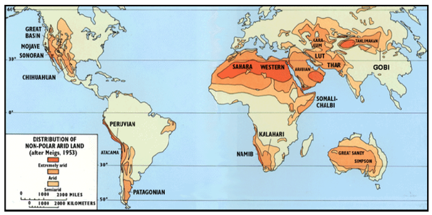
DESERT BIOMES (05:06 PM)
- Basic Characteristics- Extreme aridity, Dryness, Scattered plants, No permanent rivers, Temporary stream can be there, No woody plants like Cactii.
- Hot Tropical desert- Sahara, Thar, Kalahari
- Middle latitude desert- Gobi desert of China & Mongolia.
- Adaptations
- Photosynthesis is carried out by Stem. It reduces transpiration loss.
- Plants are of short height.
- Leaves are very thick and they try to conserve water, Leaves are waxy. Thick outer cover for leaf.
- Plant hibernation/ Plant inactivity- Plants dry up for a very long period, and when water is available, they grow up. Example- Algae
- Shrubs are also found in these desert biomes- For example- Wild Date (Water stress adaptation).
- Animal life-
- Very very diverse. Carnivores as predators which are present here are Nocturnal in nature.
- Very short larval pupil stage- This stage is completed very fast so that they can reduce the overall demand for food.
- Insect population is very large.
- Birds such as owls, Eagles are found. They feed on insects.
- Vegetation- Xerophytic vegetation.
-
- Question- Why the Hot deserts are rich in Salt?
- Answer-a) They are rich in salt composition because the water from underground aquifers is pulled up due to the dry atmosphere. The water evaporates and the soil remains with the salt.
- b) The rainfall is less, and thus the rainwater is not able to leach the salt back into the earth.
- c) The wind is the desert's primary agency and deposits the salt from the adjoining areas.
- Major representatives of Desert Biomes
- A permanent waterbody can exist in the lake and they are called Oasis.
- Sahara desert (World's biggest desert), Kalahari, Atacama desert, Californian desert, Gobi desert (China and Mongolia), Ordos desert.
MARINE BIOME (05:35 PM)
- The entire ocean is one biome only because everywhere ocean is having saline water and each ocean is interconnected with the other. So the entire ocean is having homogenous character.
- In the entire ocean, sunlight is limited to the narrow shelf (Up to 200 meters). Everywhere the producers are the same.
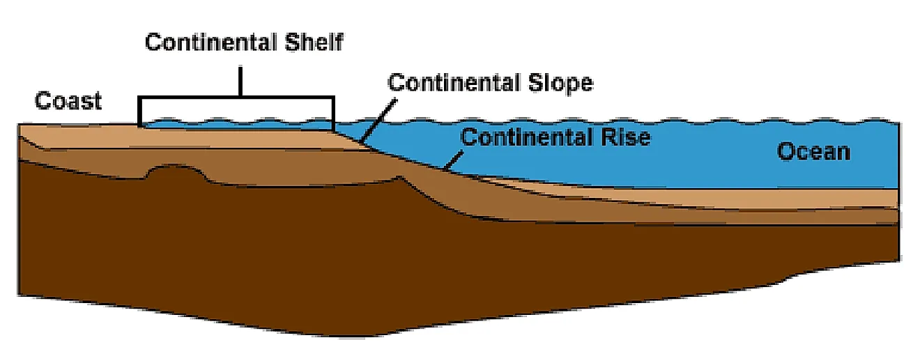
- Marine biome= 3 zones= Continental shelf, Continental shelf, and Deep sea.
- Based on depth the ocean biome is divided into zones- Littoral zones, Bathyal zone, and Abyssal zone
- Based on light- Photic zone, and Aphotic zone.
- Benthic lifeforms- The benthos is comprised of all the organisms that live at the bottom of a body of standing or running water.
- Lifeforms of the marine biome which are active swimmers- Nekton (Mostly vertebrates, mostly Fish). [* These are not mutually exclusive categories. Nekton can also be benthic as well as Benthic lifeforms can also swim].
- Phytoplanktons- They are microscopic plants. These are mostly Alage, Diatoms. They are floating and drifting plants. They flow with the current. These phytoplanktons are the greatest primary producers of the ocean biome.
- [* Oceans are absorbing the Co2- Because the Phytoplanktons are absorbing most of the carbon dioxide]
- Zooplankton- They are microscopic to all-sized animals. Microscopic zooplanktons are Protozoans, Coral polyps, and the Larval stage of animals.
- Periphytons- They do not carry locomotion, they are attached to either rock of the sea floor or the shell of the animal. These are algae-like life forms. They are called sessile.
- Trenches- They represent the deep floor of the ocean. They represent the Hadal zone. They represent the trench and its water. They have deep bacteria. They have non-photosynthetic plants. They are detritovores. They can also feed on inorganic substances such as clay-like substances. Animals found here are Sea Anemone, Sea cucumbers.
- Marine scavengers/ Scavenger life forms- Octopus, Squid
- Neuston refers to lifeforms that live at the interface of water Surface and atmosphere called the Air-water junction. Examples- Lotus, Water lilies, and some species of Fish which live directly on the surface of the water are examples of Neuston.
FOREST AND FOREST ECOSYSTEM (06:00 PM)
ECOLOGICAL FUNCTIONS OF FOREST
- Forest definition as per ISFR report- The forest cover is defined as all land, at least 2 hectares, with a tree canopy density of more than 10 percent irrespective of ownership and legal status.
- Ecological definition- Forest refers to a closed community of plants providing some amount of ground shade and it should show some kind of stratification, and it should be rich in lifeforms, where plants are close to the similarity of species as well as they should be close physically also. [* Sharing the vegetation characteristics].
- Ecological functions of the forest
- Forests directly participate and indirectly influence the soil-making process (Piedogenic processes).
- a) Forest contributes to litter and it will undergo decay and release nutrients. Those nutrients are available to plants.
- b) Litter acts as food for insect lifeforms. Insects physically move the soil, they expose the deep soil to heat and water. They also die and their death and decay add nutrients to soil.
- c) Trees slow down the surface runoff. It means more water is entering into the deep layer of soil. This will start chemical action and this is a must for soil formation. They change the mineral composition and promote chemical weathering.
- Note- Soil is a collection of organic and inorganic matters of any thickness which is capable of sustaining life forms. Soil properties do not match the original property of the parent material as the water chemically changes the properties of the mineral during the soil formation process.
- Note- Forests also help in soil formation by slowing down runoff and helping the waters enter the sub-surface region. This water now enters into the chemical reactions with rocks or minerals of rocks and breaks them down chemically, altering their properties so that minerals are undergoing a change in composition to form soils.
- d) They influence and regulate regional climate/ local climatic conditions/ global climatic conditions- They absorb the CO2 and store them. They are reducing the CO2 and reducing the air temperature. Forests reflect back the incoming solar radiation (Albedo- The forest has an Albedo of 18% ) thus they decrease the air temperature.
- Forests also influence regional climate by participating in the hydrological water cycle, [* When the temperature is high then a normal tree transpires 5 tonn of groundwater to the atmosphere. This transpiration increases the moisture content and it influences the rainfall].
- Forests also influence evaporation. The deep roots puncture the ground and thus water gets evaporated.
- e) They influence and participate also in local regional hydrological cycles- They help in water movement through evaporation and transpiration. They play an important role in the recharging of groundwater.
- In the course of the river, there are 1000s of springs that feeds the river and it maintains the flow of water. Example- Peninsular River. Recharge areas are called catchment areas.
- Example- Shola rainforests (Nilgiri Hills) have a high water retention capacity than any other soil. These forests absorb the monsoon rain and they retain them with the soil. The retained water is then slowly released in the year's course and they form small streams. They are the source of water in rivers like Cauvery/ Kaveri, Vaigai. These rivers are Perennial and never dry up.
- f) Forests create habitats for different life forms- They are creating habitats by influencing the presence of waterbodies in the forms of lakes and ponds. They create habitats by providing primary production. Tree cover is home to Mammal lifeforms, Birds lifeforms, etc. They also help in the development of soil.
- g) Forests are reserves of bio-diversity as they include different ecosystems.
- h) Forests reduce the intensity and frequency of Natural Hazards such as Floods, Landslides, Avalanches, and Soil erosion.
DEFORESTATION AND FOREST DEGRADATION (07:22 PM)
- Deforestation- It means converting forest land for non-forest use and not giving a chance to forest for regeneration. This is a permanent loss of forest. It can be converted to pasture land, agricultural land, or for Industrial purposes.
- Degradation also is also the removal of forest cover, but there is a small opportunity for the forest to regenerate and also there are chances that the complete forest has not been converted.
- Example- Shifting cultivation- A patch of forest land is burnt and agriculture is practised. After 6-7 years they leave the patch and select another patch. After some years the forest in the first patch grows back. This is an example of Degradation.
- Loss of forest
- In the last 10000 years i.e. since 8000 BC till now, Planet Earth losing 2 billion hectares of forest land which amounts to 1/3rd of the original forest cover of planet Earth.
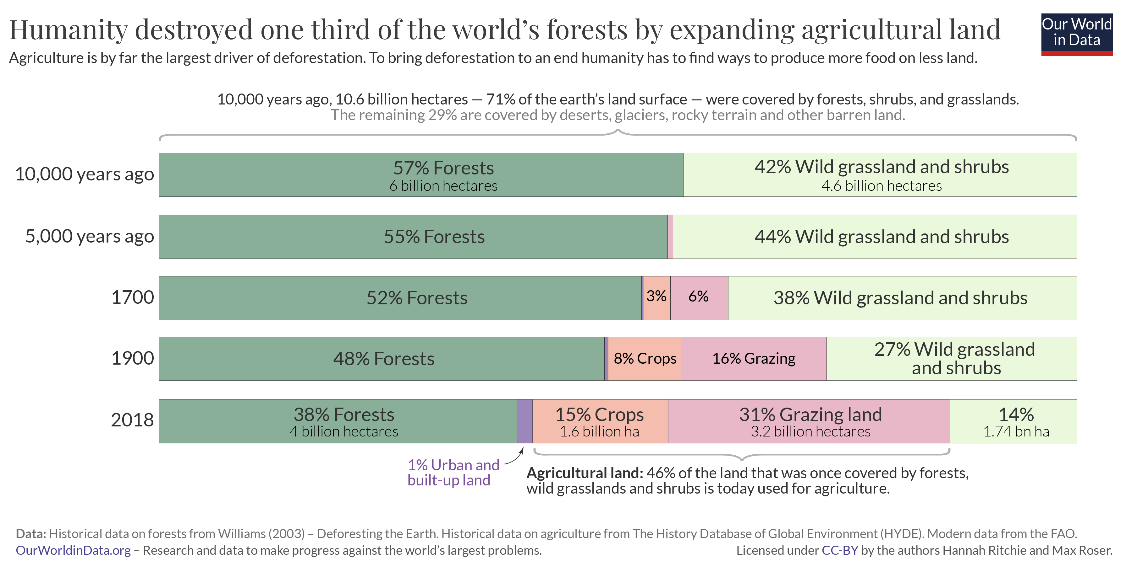
- Over 8000 years, we lost 1 billion hectares and after that, in just 120 years we have lost 1 billion hectares. It signifies that rapid population growth, rapid industrial development, and rapid urban development are the main culprits.
- After the 1900s the rate of deforestation and forest degradation have been extremely rampant.
- Between 1700 and 1850, the world lost only 19 million hectares of forest each decade.
- Between 1850 and 1920, massive population growth in European countries, and rapid industrialization led to the loss of 30 million hectares each decade.
- Between the 1920s and 1980, the world was losing 120 million hectares per decade. This was happening in Tropics.

- [* The quality of forests in Tropics is highly rich in bio-diversity, and the loss of the forest is alarming ]
- Post-1920, deforestation generally shifted towards the tropics.
- Biggest regions- Asia (Asia's monsoon forest, Asia's Savanah forest), South America (Amazon Basin, Savanahs of South America).
- Between 1980 and 1990, the world lost 150 million hectares of forest cover and much of it was in Asia's forest and Amazon's forest.
- After 1980-1990, the rate of deforestation slowed down.
- Today, the rate of deforestation is 5-6 million hectares per annum or 50-60 million hectares per decade. And 95% of this deforestation is happening in Latin America and Asia. Nearly 60% of this is in South America.
CAUSES/ REASONS FOR DEFORESTATION (07:48 PM)
- 1) Conversion of forest land to agriculture, to pasture land, to mining, to infrastructure
- Nearly 30% of today's deforestation is due to conversion to agriculture, mining, and ranching. Earlier to present times, huge areas of forest were converted to agriculture and ranching in the Savannahs of Africa, South America, and in the temperate grasslands of North America and South America.
- Today, the same pattern of conversion of forest land into agriculture and pasture is taking place in the tropics of Africa, the Amazon of South America, and the tropics of South East Asia and South Asia.
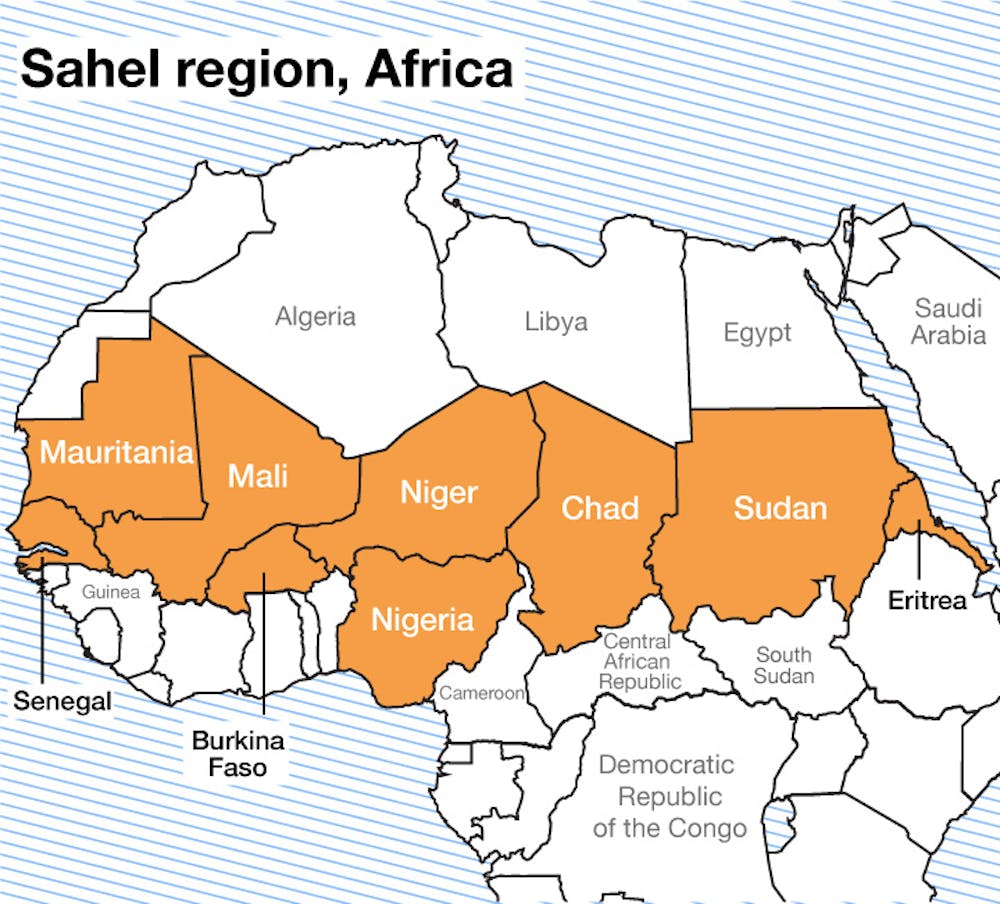
- Example- Sahel Region in Africa. When Europeans colonized Africa, they introduced livestock grazing on a very large scale in the savannah region near to Sahara desert, as their dietary preference is meat. This region was overgrazed by livestock in 200 years. This wiped out the Savanah region and it became an extended region of the Sahara desert called as Sahel region.
- 2) Timber extraction because of commercial logging accounts for nearly 25% of deforestation and degradation today. This has consumed huge areas of forest cover in Europe and North America earlier and is consuming forests of Asia, South America, and Africa today because of the export of timber to the industrialized country of the West.
- 3) Shifting cultivation is the major factor responsible for forest degradation in the Tropical regions of Asia, South America, and Africa. This consumes rich tropical forests because it is practised by indigenous communities living in Mountainous regions.
- [* For the forest to perform normal ecological functions in Mountainous regions, the minimum requirement of forest cover is 66%, and in plains, the minimum requirement is 30%].
- 4) Forest fires and Wildfires are the fourth biggest cause of forest degradation. These wildfires and Forest fires are because of both Man-made and natural causes. Most wildfire-related forestry degradation is part of the tropical and subtropical regions.
- 5) Development projects like huge multipurpose dams with huge reservoirs, large-scale mining activity, and energy projects in mountainous regions have led to large-scale deforestation and forest degradation.
- 6) Overgrazing by livestock is an important mechanism for forest degradation and deforestation in semi-arid to Arid tropical regions. Here the grassland and forest ecosystems are very weak and therefore overgrazing wipes out the grass and the Bush and the Shrub very easily.
The topic for the next class:- Forest fires- Reasons in India, Types of forest, Protected areas, Bio-diversity.